Data Requirements
YETI is a street level model. This means that the road network you want to calculate emissions for needs to be divided into street links.
Find example datasets in example/example_berlin_format_data and example/example_yeti_format_data.
The two data classes
We differentiate between berlin_format and yeti_format.
berlin_format is data in the format that we were using at the start of
this project. It is not ideal for the calculations and needs to be
transformed to a different format more suitable for the emissions
calculation.
yeti_format is data in a unified format. It defines a layer of abstraction between the
berlin_format data and the emission calculation. We provide functions to
transform berlin_format data to yeti_format data for all Strategies.
The data that you are working with is likely in a different
format than our berlin_format, however chances are that you can
tranform your data to fit the yeti_format. If this is the
case, you only need to
write a function to convert your data
to yeti_format. Once this is done you can use YETI with your data and
don’t need to adapt any other part of the system.
Data requirements depend on Strategy
The data requirements depend on how you want to calculate emissions. For example calculating emissions with the COPERT methodology requires different input data than a calculation with the HBEFA methodology.
Take a look at the docs page of the Strategy you want to use to find out about the data requirements for that Strategy.
File format
All data files are csv files. They use comma (‘ , ‘) as seperator and the dot (‘ . ‘) for decimal points.
berlin_format
All Strategies need the following three files in berlin_format:
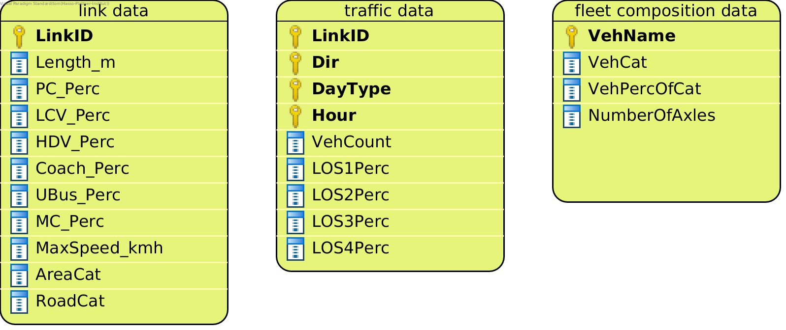
link data
This is a file with data about the street links in the region you are examining. Each street link corresponds to one line in the link data file. These are the columns:
- LinkID: The unique ID for the street link
- Length_m: The length of the link in meters
- AreaCat: The area category for the street link. Currently allowed area categories are:
0for rural and1for urban. If your input data uses different categories, you can change the data loading behaviour to support other categories. - RoadCat: The road category for the street link. Currently allowed area categories are listed below. If your input data uses different categories, you can change the data loading behaviour to support other categories.
6 = Motorway-Nat.
5 = Motorway-City
9 = Trunk road / Primary-Nat.
8 = Trunk road / Primary-City
1 = Distributer / Secondary
3 = Loacal / Collector
0 = Access-residential
- MaxSpeed_kmh: The legal maximum speed for the street link in km/h
- PC_Perc: The percentage of passenger cars of total traffic at the link
- LCV_Perc: The percentage of light commercial vehicles of total traffic at the link
- HDV_Perc: The percentage of heavy duty vehicles of total traffic at the link
- Coach_Perc: The percentage of coaches of total traffic at the link
- UBus_Perc: The percentage of urban buses of total traffic at the link
- MC_Perc: The percentage of motorcycles and mopeds of total traffic at the link
Example:
| LinkID | AreaCat | RoadCat | MaxSpeed_kmh | PC_Perc | LCV_Perc | HDV_Perc | Coach_Perc | UBus_Perc | MC_Perc |
|---|---|---|---|---|---|---|---|---|---|
| 42_123 | 0 | 5 | 100 | 0.4 | 0.2 | 0.05 | 0.15 | 0.1 | 0.1 |
| 65_485 | 1 | 3 | 30 | 0.8 | 0.05 | 0 | 0 | 0.1 | 0.05 |
traffic data
This file contains the total vehicle count at for each street link, direction, day type and hour. It also contains the distribution of traffic across the different levels of service. It has these columns:
- LinkID: The unique ID for the street link. The LinkIDs need to match the LinkIDs in the link data.
- Dir: The traffic direction for the given street link:
0 = left
1 = right
- DayType: One of four day types:
1 = Monday to Thursday
2 = Friday
3 = Saturday
7 = Sunday or Holiday
- Hour: A number between 0 and 23.
- VehCount: The total number of cars at the given street link for the given day type, hour and direction.
- LOSxPerc: The percentage of traffic attributed to the x level of service. Currently implemented levels of service: 1 (Freeflow), 2 (Heavy), 3 (Satur.), and 4 (St+Go).
Example:
| LinkID | Dir | DayType | Hour | VehCount | LOS1Percentage | LOS2Percentage | LOS3Percentage | LOS4Percentage |
|---|---|---|---|---|---|---|---|---|
| 42_123 | 0 | 1 | 0 | 4 | 1 | 0 | 0 | 0 |
| 65_485 | 1 | 7 | 9 | 80 | 0.2 | 0.5 | 0.4 | 0.1 |
fleet composition data
This file contains data on the composition of the fleet. The fleet composition applies to all links. It contains these columns:
- VehName: The name of a vehicle class. For example
PC petrol <1.4L Euro-1. - VehCat: The category of the vehicle. Possible vehicle categories are:
- P = passenger cars
- L = light commercial vehicles
- S = heavy duty vehicles
- R = coaches
- B = urban buses
- Moped = mopeds
- M = motorcycles
- VehPercOfCat: The percentage of the vehicle with regard to all vehicles of its category. Should be between 0 and 1.
- NumberOfAxles: The number of axles for the given vehicle. This is only relevant for vehicles belonging to one of
these categories:
S,R, orB. This column needs to be present, however its contents are only used for the StrategyPMNonExhaustStrategy. So if you don’t have the number of axles data, you can leave the column blank for all other Strategies.
Example:
| VehName | VehCat | VehPercOfCat | NumberOfAxles |
|---|---|---|---|
| PC petrol <1.4L Euro-1 | P | 0.2 | |
| LCV diesel M+N1-I Euro-2 | L | 0.003 |
yeti_format
All Strategies work with these yeti_format datasets:
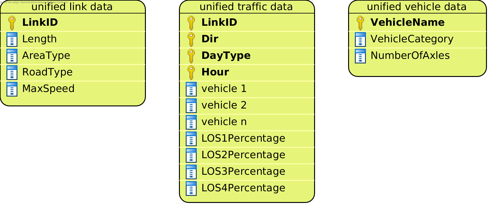
yeti_format link data
This is a file with data about the street links in the region you are examining. Each street link corresponds to one line in the yeti_format link data file. It has these columns:
- LinkID: The unique ID for the street link
- Length: The length of the link in kilometers
- RoadType: The road type for the street link. Possible road categories are:
RoadType.MW_Nat = Motorway-Nat.
RoadType.MW_City = Motorway-City
RoadType.Trunk_Nat = Trunk road / Primary-Nat.
RoadType.Trunk_City = Trunk road / Primary-City
RoadType.Distr = Distributer / Secondary
RoadType.Local = Loacal / Collector
RoadType.Access = Access-residential
- AreaType: The area type for the street link. Possible area categories are:
AreaType.Urban = rural
AreaType.Rural = urban
- MaxSpeed: The legal maximum speed for the street link in km/h.
Example:
| LinkID | AreaType | RoadType | MaxSpeed |
|---|---|---|---|
| 42_123 | AreaType.Rural | RoadType.MW_City | 100 |
| 65_485 | AreaType.Urban | RoadType.Local | 30 |
yeti_format traffic data
This file contains vehicle count data for every vehicle in yeti_format vehicle data and for each street link, direction, day type and hour. It has these columns:
- LinkID: The unique ID for the street link. The LinkIDs need to match the LinkIDs in the yeti_format link data.
- Dir: The traffic direction for the given street link:
Dir.R = right
Dir.L = left
- DayType: One of four day types:
DayType.MONtoTHU = Monday to Thursday
DayType.FRI = Friday
DayType.SAT = Saturday
DayType.SUN = Sunday or Holiday
- Hour: A number between 0 and 23.
- vehicle i: The number of vehicles belonging to class
vehicle iat the street link for the given day type, hour and direction. The file needs to contain vehicle count columns for all vehicle names in the yeti_format vehicle data. - LOSxPercentage: The percentage of traffic attributed to the x level of service. Currently implemented levels of service: 1 (Freeflow), 2 (Heavy), 3 (Satur.), and 4 (St+Go).
Example
| LinkID | Dir | DayType | Hour | PC petrol <1.4L Euro-1 | LCV diesel M+N1-I Euro-2 |
|---|---|---|---|---|---|
| 42_123 | Dir.L | DayType.MONtoTHU | 0 | 0.32 | 0.0023999999 |
| 65_485 | Dir.R | DayType.SUN | 9 | 12.8 | 0.012 |
yeti_format vehicle data
A dataset linking each vehicle class to its category.
- VehicleName: The name of a vehicle class. For example
PC petrol <1.4L Euro-1. - VehicleCategory: The vehicle category the vehicle class belongs to. These are the possible categories:
VehicleCategory.PC = passenger cars
VehicleCategory.LCV = light commercial vehicles
VehicleCategory.HDV = heavy duty vehicles
VehicleCategory.COACH = coaches
VehicleCategory.UBUS = urban buses
VehicleCategory.MOPED = mopeds
VehicleCategory.MC = motorcycles
- NumberOfAxles: The number of axles for the given vehicle. This is only relevant for vehicles belonging to one of
these categories:
VehicleCategory.HDV,VehicleCategory.COACH, orVehicleCategory.UBUS. This column needs to be present, however its contents are only used for the StrategyPMNonExhaustStrategy. So if you don’t have the number of axles data, you can leave the column blank for all other Strategies.
Example
| VehicleName | VehicleCategory | NumberOfAxles |
|---|---|---|
| PC petrol <1.4L Euro-1 | VehicleCategory.PC | |
| LCV diesel M+N1-I Euro-2 | VehicleCategory.LCV |